Wednesday, August 24, 2016

Mendenhall Ice Caves, Juneau, Alaska

Mendenhall Ice Caves, Juneau, Alaska


The Mendenhall Glacier is a 12-mile-long glacier in the Mendenhall Valley, located only 12 miles from downtown Juneau in Southeast Alaska. Federally protected as part of the Mendenhall Galcier Recreation Area, a unit of the Tongass National Forest, the glacier originally had two names, Sitaantaagu ("Glacier Behind the Town") and Aak'wtaaksit ("Glacier Behind the Little Lake").


The Ice Caves are inside the glacier, accessible only to those willing to kayak to, and then ice climb over the glacier. However, the glacier is retreating increasingly fast as global warming heats the oceans and temperatures rise.


Monitored since 1942 by the Juneau Icefield Research Program, the Mendenhall Glacier has receded almost two miles since 1958, while previously it had receded only 0.5 miles since 1500. The caves are in part a function of this increased glacial melting.


Saturday, August 20, 2016


Angel Falls, Canaima Venezuela


The waterfall has been known as the "Angel Falls" since the Mid-20th century; they are named after Jimmie Angel, a US aviator, who was the first person to fly over the falls. Angel's ashes were scattered over the falls on 2 July 1960


The common Spanish name Salto Ángel derives from his surname. In 2009, President Hugo Chávez announced his intention to change the name to the purported original indigenous Pemon term ("Kerepakupai Vená", meaning "waterfall of the deepest place"), on the grounds that the nation's most famous landmark should bear an indigenous name.


Angel Falls is one of Venezuela's top tourist attractions, though a trip to the falls is a complicated affair. The falls are located in an isolated jungle. A flight from Puerto Ordaz or Ciudad Bolívar is required to reach Canaima camp, the starting point for river trips to the base of the falls. River trips generally take place from June to December, when the rivers are deep enough for use by the Pemon guides. During the dry season (December to March) there is less water seen than in the other months.


Outdoor sports: The dramatic sandstone table-top mountains, the tepuis, Roraima and Auyántepui (the Devils Mountain) in Canaima National Park's Gran Sabana region provide good opportunities for challenging outdoor activities such as mountain climbing in Canaima and trekking in Angel Falls.


Angel Falls also inspired the setting of the Disney animated film Up (2009) although, in the film, the location was called Paradise Falls instead of Angel Falls. It also makes a small appearance in the Disney film Dinosaur, as well as the 1990 film Arachnophobia. Most recently, it makes an appearance in the 2015 film Point Break.


Location:


Saturday, August 13, 2016

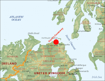
Giant's Causeway, Northern Ireland


 The Giant's Causeway is an area of about 40,000 interlocking basalt columns, the result of an ancient volcanic eruption. It is also known as Clochán an Aifir or Clochán na bhFomhórach in Irish and tha Giant's Causey in Ulster-Scots.


The Giant's Causeway, renowned for its polygonal columns of layered basalt, is the only UNESCO World Heritage Site in Northern Ireland and in 2015 was awarded the UKs Best Heritage Attraction at the British Travel Awards. 


Flora and Fauna
The area is a haven for seabirds such as fulmar, petrel, cormorant, shag, redshank, guillemot and razorbill, while the weathered rock formations host a number of rare and unusual plants including sea spleenwort, hare's-foot trefoil, vernal squill, sea fescue and frog orchid


stromatolite colony was reportedly found at the Giants Causeway in October 2011 – an unusual find as stromatolites are more commonly found in warmer waters with higher saline content than that found at the causeway


The Giant’s Causeway is also steeped in myth and legend. Some say it was carved from the coast by the mighty giant, Finn McCool who left behind an ancient home full of folklore. Look out for clues of his existence


For centuries countless visitors have marvelled at the majesty and mystery of the Giants Causeway. At the heart of one of Europe's most magnificent coastlines its unique rock formations have, for millions of years, stood as a natural rampart against the unbridled ferocity of Atlantic storms. The rugged symmetry of the columns never fails to intrigue and inspire our visitors. To stroll on the Giants Causeway is to voyage back in time.


Your imagination will travel along stepping stones that lead to either the creative turbulence of a bygone volcanic age or into the mists and legends of the past.


Location:


Saturday, August 6, 2016

Badab-e Surt, Iran


These beautiful travertine terraces in Northern Iran are an incredible natural phenomenon that developed over thousands of years. Travertine is a type of limestone formed from the calcium deposit in flowing water, and in this case it's two hot springs with different mineral properties. The unusual reddish colour of the terraces is down to the high content of iron oxide in one of the springs.


Badab is a Persian compound of Bād "gas" + āb "water", translating to "gassed water", referring to the springs' waters being carbonated mineral waters. Surt is an old name for the Orost village and a Persian word meaning intensity.


Badab Soort's springs are two distinct mineral springs with different natural characteristics, located at 1,840 metres (6,040 ft) above sea level. The first spring contains very salty water that gathers in a small natural pool, its water is considered to have medicinal properties, especially as a cure for rheumatism and some types of skin diseases and skin conditions. The second spring has a sour taste and is predominately orange mainly due to the large iron oxide sediments at its outlet.


When and how to get there???
You can choose your weather – winters are mild and rainy, while summers are hot and dry.
You can go there by plane, train or bus get to Sari from Tehran. Then catch a taxi to Badab-e Surt through Kiasar.


Hot mineral springs fill the pools with healthy, very salty water, which heals rheumatism and various skin conditions. Visitors can hike around, enjoy the views and wade these pools, but waterproof footwear is advised. Tourists also can set a camping site nearby and enjoy the tranquility of unspoiled nature – there are no wild dangerous animals around.


Saturday, July 30, 2016

Mount Roraima, South Africa


Mount Roraima is one of the oldest mountain on Earth, a natural border between Venezuela, Brazil and Guyana in South Africa.


It is also known as Roraima Tepui or Cerro Roraima. It is one of the highest peak in Tepui plateau in the South Africa.


Mount Roraima, part of Venezuela's 30000 square kilometers Canaima National Park, is the site of the highest peak of the country of Guyana's Highland Range.Daily rain  have also created a unique ecosystem which includes several endemic species, such as a unique carnivorous pitcher plant, and some of the highest waterfall in the world.


Mount Roraima was considered a symbol of these region, an "axis mundi", an enormous tree within which all the vegetable and fruits of the world grow.
It is surrounded by 400 meter(1,300ft) tall cliffs was a place of mystery, myths, and legends for the indigenous people that live here centuries ago.


The Tepui was the first major one in the world to be climbed when in 1884, Sir Evererd im Thum took a forested trail that took him to plateau. The same trail is the one used by other hikers today as they make their way through the caps and though terrain to get the top.


Never leave after 2 p.m. from the village as the trekkers  are no longer allowed after this hour. At the beginning of your climb, your baggages will be strictly checked and you cannot take more that  kilos with you. You are also not permitted to take rocks or plants along the way.


The top of the mountain measures  2,772 m, it offer amazing landscapes and establishing a tent around here is possible. However, you should know the whether changes suddenly in this area so be prepared.


Friday, July 22, 2016

Vadhoo Island, Maldives

Vadhoo Island, Maldives


The Vaadhoo Island is located on the equator to the SW(South West) of Sri Lanka, in the Indian Ocean of Maldives. Sea-loving couples will fall in love with this place just by looking at pictures. It is a mix of romance with marine life and activities that have never disappointed tourists so far.


But Vaadhoo is not only famous for the glow in the dark beaches. Due to this phenomenon, red algae bloom a lot faster and cause “the red tide”. The beach turns red as it acts like a defense mechanism to distract predators.


How to get there
Vaadhoo is actually a small island (not bigger than 250 x 100 m), making it the perfect honeymoon getaway, but also the ideal escapade for all those looking to spoil themselves and relax far away from the city rush. It is located 8 km away from the airport and you can get there by Motor Dhoni. To get to Vaadhoo, the cheapest and easiest way is to catch the Island Ferry. However, if you are in the capital, know that it takes 1 day to reach Vaadhoo Island.


This phenomena has been called the “Sea of Stars” due to its glowing blue waves. It’s definitely a fantasy-like experience but before you roll over in search for that specific beach in Vaadhoo to see the so-called Sea of Stars, better know more about the beautiful little creatures that cause this unbelievable glowing effect.


Coordinate :